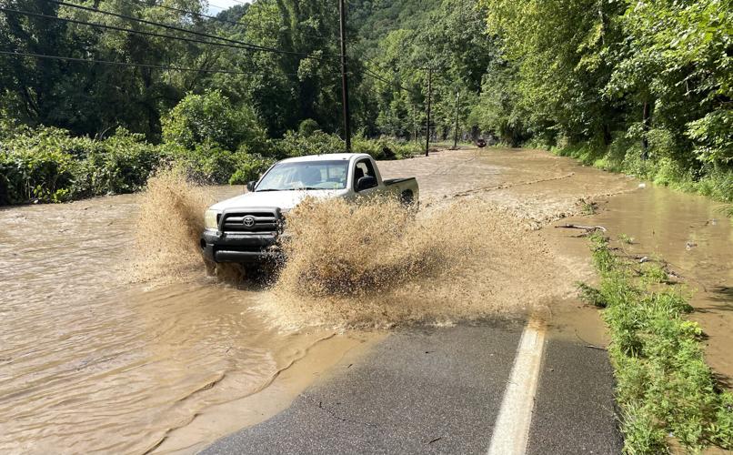
A pickup truck drives through high water near the mouth of Cabin Creek on Sunday, Aug. 16, 2026. Heavy rain early on Sunday caused flash flooding and several water rescues, according to Kanawha County emergency management officials.
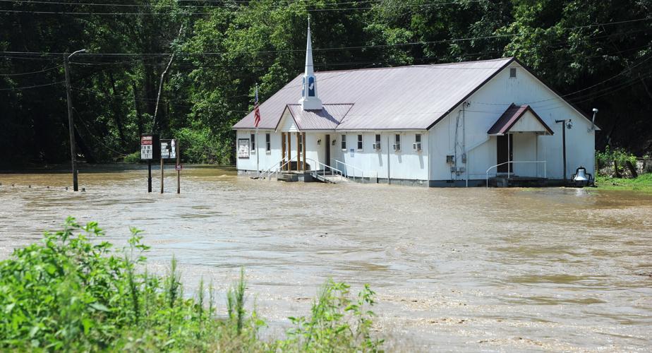
The Zion Assembly Church of God is surrounded by water from Cabin Creek on Sunday, Aug. 16, 2026, in Sharon. Heavy rain early on Sunday caused flash flooding and several water rescues in the nearby Eskdale area along Cabin Creek, according to Kanawha County emergency management officials.
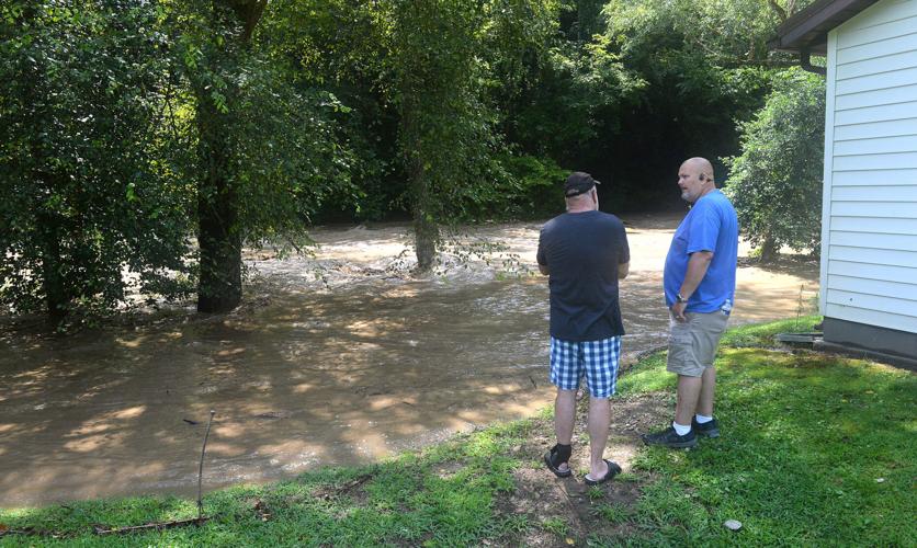
CJ Jenkins (at left) and Stuart Hudnall (at right) study the flooded Paint Creek behind the home of Jenkins' father, Carl Jenkins (not pictured), on Sunday, Aug. 16, 2026. CJ Jenkins said that Paint Creek rarely swells past the water birch trees seen at center, left.
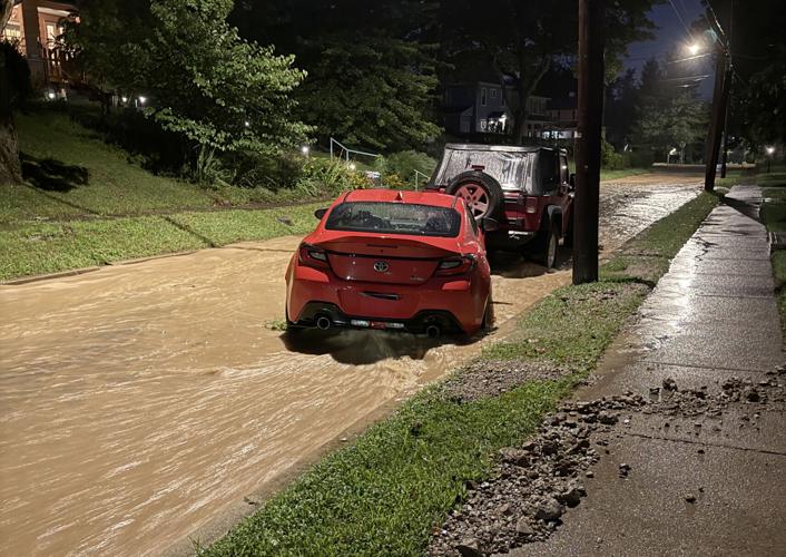
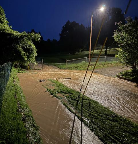
Valley Road in the Edgewood neighborhood of ÂÒÂ×ÄÚÉä was a river of water following heavy rains on Sunday, Aug. 16, 2026. This water came from Cato Park (background).
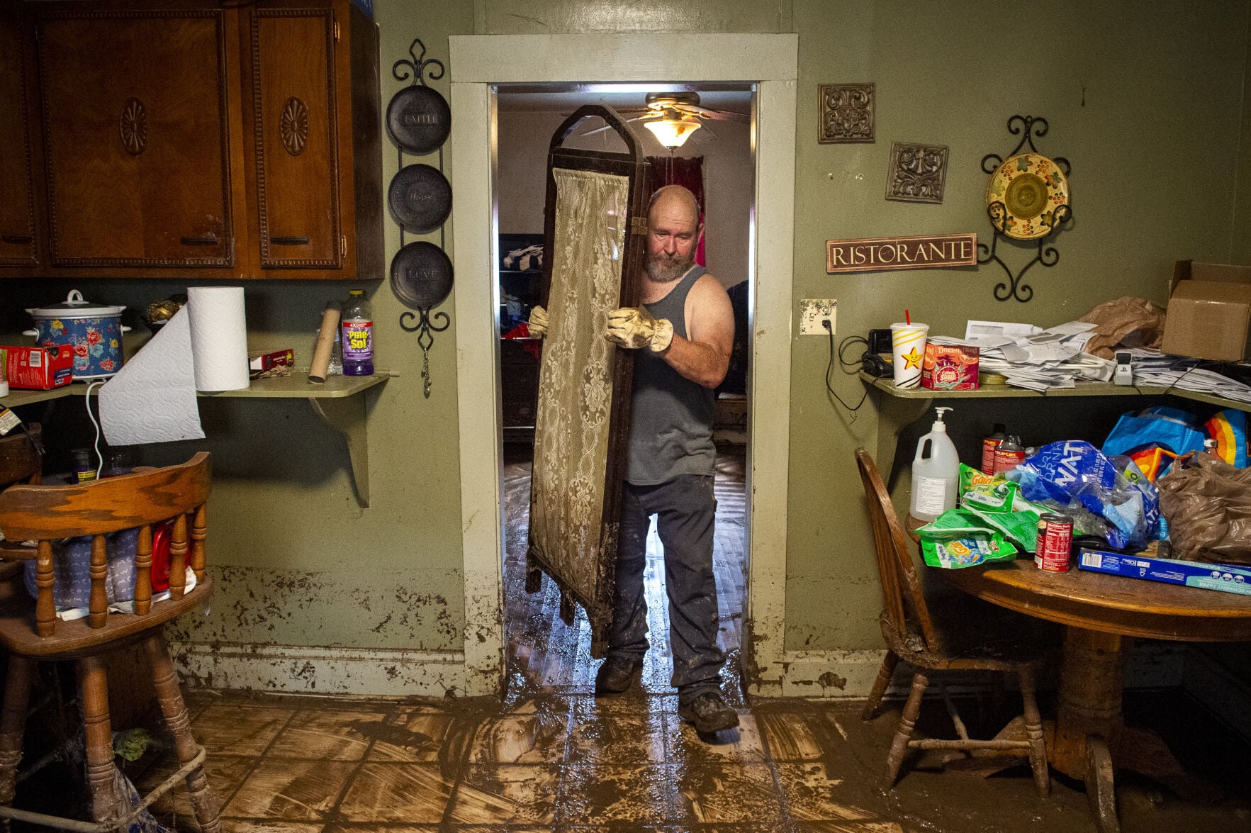
On Monday, Aug. 17, 2026, a high-water line can be seen about two feet up the wall (at right) from flooding the night before on Garrison Avenue in ÂÒÂ×ÄÚÉä.
On Monday, Aug. 17, 2026, Shane Allen, of Tornado, clears muddy debris from the home he rents out on Garrison Avenue in ÂÒÂ×ÄÚÉä. The home suffered damage from flooding on Aug. 16.
On Monday, Aug. 17, 2026, Shane Allen, of Tornado, clears muddy debris from the home he rents out on Garrison Avenue in ÂÒÂ×ÄÚÉä. The home suffered damage from flooding on Aug. 16.
LAURA BILSON | Gazette-Mail
As historic rain fell across West Virginia Sunday, more than 50 water rescue calls were logged Sunday and early Monday through Metro 911, as three distinct periods of heavy rain occurred Sunday that contributed to flash flooding throughout Kanawha County.
As of 10:30 a.m. Monday, no injuries have been reported in any of the incidents, according to Kanawha County Emergency Management Director C.W. Sigman.Ìý
A Metro 911 supervisor said — as of 4:45 a.m. Monday — that 54 calls came in, but some could have been related to the same incident.
Areas of major concern, each with about a half-dozen calls or more, included:
Garrison Avenue, ÂÒÂ×ÄÚÉä
Campbells Creek Drive, ÂÒÂ×ÄÚÉä
Cross Lanes/Tyler Mountain
Cabin Creek, specifically Eskdale
One of the rescues involved a city worker who fell into the water trying to help a person in a disabled-placarded vehicle, according to Capt. Dave Hodges of the ÂÒÂ×ÄÚÉä Fire Department. The incident took place on Garrison Avenue, and the city worker was not injured.
On Monday, Aug. 17, 2026, a high-water line can be seen about two feet up the wall (at right) from flooding the night before on Garrison Avenue in ÂÒÂ×ÄÚÉä.
LAURA BILSON | Gazette-Mail
12 p.m.: The Kanawha County Commission announced a storm damage survey in a news release Monday. They encourage residents who experienced property damage due to flooding to complete the West Virginia Emergency Management Division Weather Damage Survey at bit.ly/Kanawha_DamageAssessment.
When filling out the survey, residents should provide their address and photos of the damage, if possible, the news release said. If you can't complete the survey, you can report damage by calling the Kanawha County Planning and Development office at 304-357-0570. For additional help filling out the survey, call 211 between 8 a.m. and 4 p.m.
10:45 a.m.: City workers have been assessing damage, clearing debris and addressing impacted roadways since Sunday, City of ÂÒÂ×ÄÚÉä officials said in a news release Monday.
As they continue to respond to storm-related issues, city officials encourage anyone who has experienced storm-related damages to their property to report it in their new survey at bit.ly/CWV_DamageAssessment. The survey is not for financial assistance, but the information gathered will be shared with state and federal agencies and volunteer groups to support disaster recovery efforts.Ìý
The Martin Luther King Jr. Community Center, 314 Donnally St., is accepting disaster relief supplies, according to the news release. Needed items include:Â
Bottled water
Disinfectant cleaner
Fans and dehumidifiersÂ
Flathead shovels
Heavy-duty trash bagsÂ
Paper towelsÂ
Work glovesÂ
5-gallon buckets
More than 4 inches of rain; more expected
Sunday's rain was historic for our area, with 4.23 inches falling at the West Virginia International Yeager Airport, according to Joe Curtis, a meteorologist with the National Weather Service in ÂÒÂ×ÄÚÉä. Curtis said most areas of Kanawha County saw 2-4 inches of rain throughout the day.
Sunday's rain breaks the old daily record for Aug. 16 of 1.64 inches in 1922. The record for most rain at the airport was 5.6 inches on July 19, 1961.
"The ground is getting more and more saturated," Curtis said Monday morning. "When we get rainfall like we had yesterday, the ground just can't hold it."
Looking ahead at the National Weather Service's forecast for the week, be prepared for more rainfall and storms in ÂÒÂ×ÄÚÉä.Ìý
Monday: Showers and thunderstorms likely in the afternoon and evening; high of 84, low of 69
Tuesday: Chance of participation is 20%, with cloudy skies in the morning; high of 82, low of 64
Wednesday: Mostly sunny, with a chance of thunderstorms after 2 a.m.; high of 86, low of 68
Thursday: Showers and thunderstorms are likely all day, with mostly cloudy skies. High of 82, low of 65Â
Friday: Partly sunny with a 50% chance of rain during the day, cloudy skies and a 30% chance of rain in the evening; high of 81, low of 65
Water rescues in ÂÒÂ×ÄÚÉä
Valley Road in the Edgewood neighborhood of ÂÒÂ×ÄÚÉä was a river of water following heavy rains on Sunday, Aug. 16, 2026. This water came from Cato Park (background).
ZION GODFREY | Courtesy photo
8:30 p.m.: Flooding in ÂÒÂ×ÄÚÉä is prompting water rescues in several areas of Garrison Avenue, the 1000 block of Bullitt Street and other locations as heavy rain fell across ÂÒÂ×ÄÚÉä Sunday evening, according to Metro 911. The intersection of Rutledge Road and Greenbrier Street was also flooded Sunday evening as Elk Twomile Creek came out of its banks after heavy rain passed through.
Knee-high water was reported on ÂÒÂ×ÄÚÉä's West Side in the area of Green and Stockton streets.
Other ÂÒÂ×ÄÚÉä locations reporting high water Sunday night included:
1500 block of Hubbard Road
First block of Meadowbrook Drive
1700 block of Chandler Drive
1700 block of Sugar Creek Drive
2000 block of Bakers Fork Road
900 block of Mathews Drive
'I've never seen it like this'
8:30 p.m.: Zion Godfrey shot video — posted to Facebook by his wife Emily Halen — showing water gushing like a river down Valley Road at Swarthmore Avenue in ÂÒÂ×ÄÚÉä Sunday night around 8:30 p.m. The water filled the entire width of the street as it flowed from the Cato Park area downhill on Valley Road toward West Washington Street on the West Side.
"I grew up on that street," said Godfrey, who still lives in the area. "It's flooded before. I've never seen it like this."
Valley Road in the Edgewood neighborhood of ÂÒÂ×ÄÚÉä was a river of water following heavy rains on Sunday, Aug. 16, 2026.
ZION GODFREY | Courtesy photo
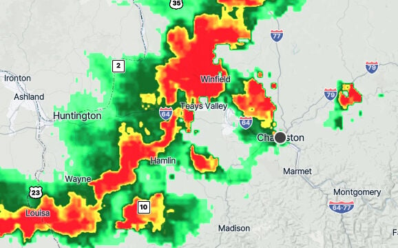
Severe Thunderstorm, Flash Flood warnings for central W.Va.
The National Weather Service has issued a severe thunderstorm warning for Kanawha County through 8:15 p.m. on Aug. 16, 2026.
Courtesy image
7:45 p.m.: A Severe Thunderstorm Warning has been issued for central West Virginia including Cabell, Putnam and Kanawha counties through 8:15 p.m., by the National Weather Service.
Expect heavy rain and 60 mph wind gusts and up to ¾-inch diameter hail.
There is also a Flash Flood Warning for most of Kanawha County through 8:45 p.m. The NWS expects between 1½ and 2½ inches of rain to fall across the ÂÒÂ×ÄÚÉä area during that time.
'Flooding all over Kanawha County'
4:30 p.m.: Storms pounded Kanawha County, leading to high water and water rescues from Cross Lanes to Cedar Grove. Incidents were reported by Metro 911 at:
Victoria Road and Big Tyler Road, Tyler Mountain
4900 block of Washington Street West, Cross Lanes
600 block of Melody Lane, Tyler Mountain
Rocky Lane, Cross Lanes
500 block of Hull Avenue, Cedar Grove
5000 block of Washington Street, West, Cross Lanes
5200 block of Dalewood Drive, Cross Lanes
Campbells Creek Drive, Tad
700 block of Days Drive, Campbells Creek
"There's flooding all over Kanawha County," said Sigman at around 6:30 p.m. Sigman chased flooding calls all day through the storms.
Sigman said there were no reported injuries at that time.
The Zion Assembly Church of God is surrounded by water from Cabin Creek on Sunday, Aug. 16, 2026, in Sharon. Heavy rain early on Sunday caused flash flooding and several water rescues in the nearby Eskdale area along Cabin Creek, according to Kanawha County emergency management officials.
CHRISTOPHER MILLETTE | Gazette-Mail
12:30 p.m.: Water rescues kept emergency crews busy Sunday morning as early-morning rains prompted the National Weather Service to put southeastern Kanawha County under a Flash Flood Warning at 8:41 a.m. Between 2 and 3½ inches of rain have fallen, according to the National Weather Service.Ìý
Metro 911 reported several water rescues in the Cabin Creek and area of the Upper Kanawha Valley.Ìý
"We're very busy right now," Sigman said around 10:15 a.m. "There is a lot of high water and a lot of rescues."Â
Between 10-10:30 a.m. Sunday, water rescues were reported by Metro 911 at Cove Road and Sandy Lane in Eskdale, Carbon Road in Carbon and Cove Road in Eskdale.
A pickup truck drives through high water near the mouth of Cabin Creek on Sunday, Aug. 16, 2026. Heavy rain early on Sunday caused flash flooding and several water rescues, according to Kanawha County emergency management officials.
CHRISTOPHER MILLETTE | Gazette-Mail
First responders assisted people stranded in their houses due to high water and people attempting to drive through high water, but no injuries have been reported, Sigman said.Ìý
Sigman said the most important thing for people to do is to steer clear of high water as much as possible.Ìý
"Just this morning we had two visitors ... start wading out into the water," Sigman said. "Don't do that. Stay out of the flood water."Â
Other areas of Kanawha County remain under a Flash Flood Watch until 8 a.m. Monday, as continued rainfall is expected.Ìý
Up to 1½ more inches of rain are possible, according to the National Weather Service. The Flash Flood Warning will remain in effect until 2 p.m. Sunday.
As of around 12:30 p.m., Cabin Creek was receding, according to East Bank Volunteer Fire Chief James Stamper.
CJ Jenkins (at left) and Stuart Hudnall (at right) study the flooded Paint Creek behind the home of Jenkins' father, Carl Jenkins (not pictured), on Sunday, Aug. 16, 2026. CJ Jenkins said that Paint Creek rarely swells past the water birch trees seen at center, left.
CHRISTOPHER MILLETTE | Gazette-Mail
Areas experiencing flash flooding include Chesapeake and Marmet. Cabin Creek is out of its bank in the Miami and Ronda areas, according to Chesapeake Fire Chief Jeremy Thompson.
W.Va. 61's eastbound lane is closed due to a major mudslide. The 5500 block of Paint Creek Road is also shut down due to high water, according to Metro 911.Ìý
This is a developing story. Return for updates.
CLICK HERE to follow the ÂÒÂ×ÄÚÉä Gazette-Mail and receive